Winchester's plan divides the city into 10 planning areas, all in ZIP 22601. Zillow's typical 22601 value was $349,952 in September 2026.
Last checked Oct. 19, 2026. The areas on this page are the City of Winchester’s own 10 planning areas, from Chapter 11 of its 2022 Comprehensive Plan. School zones, parks, wards and bus stops come from the city’s open GIS data; school ratings from Virginia’s School Quality Profiles; home values from the Zillow Home Value Index (Zillow Research); population from the Census Bureau’s QuickFacts.
Winchester is an independent city of 27,981 people, surrounded by Frederick County but part of no county. The city covers about 9.2 square miles, and its 2022 Comprehensive Plan divides it into 10 planning areas, drawn along the railroads and main streets. Every city address is in one ZIP code, every public school student goes to the same middle and high school, and only the elementary school depends on the address. This guide maps the areas and links a full guide to each.
What this means for you
- High school for every city address: John Handley High School, 425 Handley Blvd., rated Distinguished
- Typical home value, ZIP 22601: $349,952 in September 2026, according to Zillow
- Interstate: I-81 runs just east of the city; Exits 310, 313, 315 and 317 serve it
- School zone check: the division’s WebQuery address lookup or Winchester Public Schools, 540-667-4253
How the city is laid out
- City limits matter more than the mailing address. All 16,729 address points on the city’s map are in ZIP 22601, but ZIP codes 22602 and 22603 also carry a Winchester mailing address and are in Frederick County. A home there pays county taxes and goes to Frederick County Public Schools, not Winchester Public Schools. Check the city’s property search map before you assume.
- The main roads: U.S. 11 runs north and south as Valley Avenue and Loudoun and Cameron streets; U.S. 50 crosses east and west as Amherst Street and Millwood Avenue; U.S. 522 is Fairmont Avenue to the north; Route 7 is Berryville Avenue to the east. Interstate 81 runs along the east side of the city, outside the city line.
- The railroads are the borders. The CSX line divides the eastern areas from the rest of the city, and the Winchester and Western tracks separate West Central and Central from the southern areas.
- School zones do not follow the planning areas. Eight of the 10 areas are split between two or three of the four elementary zones on the city’s map.
Map of the planning areas
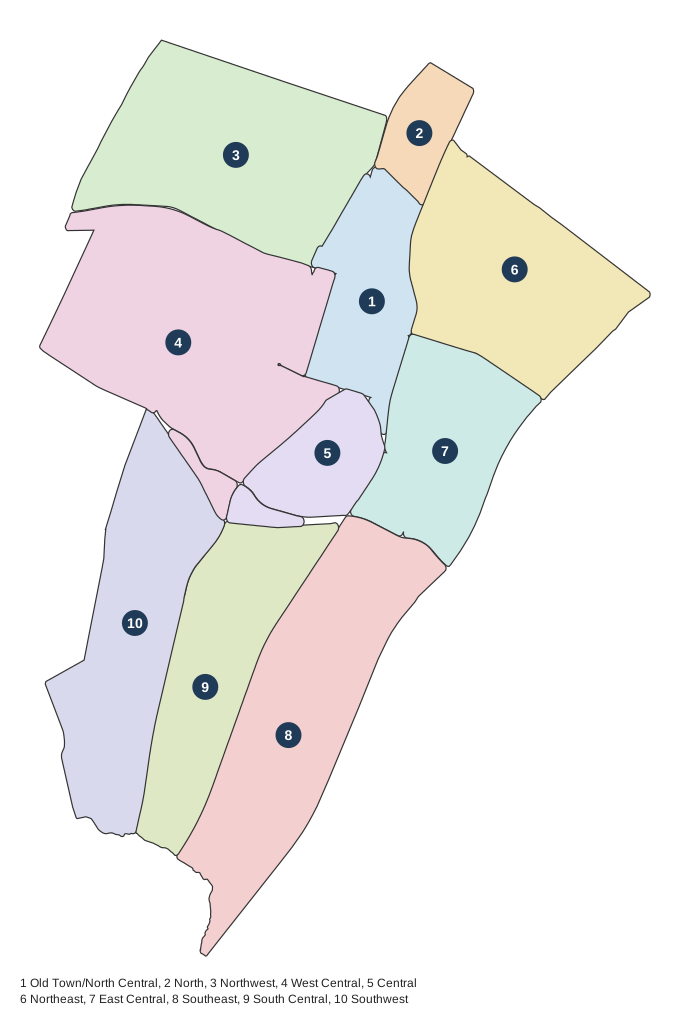
Map: Winchester Now, drawn from the boundaries the 2022 Comprehensive Plan gives in words, on the city’s street, rail and city limit GIS layers.
The areas at a glance
Elementary shares count the city’s address points in each zone on the city’s School Districts map layer. The home value is Zillow’s index for ZIP 22601 in September 2026; one ZIP covers the whole city, so it is the same for every area.
| Area | ZIP | Elementary zone (share of addresses) | High school | Typical value in its ZIP | Guide |
|---|---|---|---|---|---|
| Old Town/North Central | 22601 | John Kerr 67%, Virginia Avenue 33% | John Handley | $349,952 | Old Town |
| North | 22601 | Virginia Avenue | John Handley | $349,952 | North |
| Northwest | 22601 | John Kerr 90%, Virginia Avenue 10% | John Handley | $349,952 | Northwest |
| West Central | 22601 | John Kerr 74%, Quarles 23%, Virginia Avenue 3% | John Handley | $349,952 | West Central |
| Central | 22601 | Quarles | John Handley | $349,952 | Central |
| Northeast | 22601 | John Kerr 51%, Virginia Avenue 49% | John Handley | $349,952 | Northeast |
| East Central | 22601 | John Kerr 75%, Quarles 25% | John Handley | $349,952 | East Central |
| Southeast | 22601 | Frederick Douglass 74%, Quarles 26% | John Handley | $349,952 | Southeast |
| South Central | 22601 | Quarles 71%, Frederick Douglass 29% | John Handley | $349,952 | South Central |
| Southwest | 22601 | Quarles 57%, Frederick Douglass 43% | John Handley | $349,952 | Southwest |
Home values by ZIP code
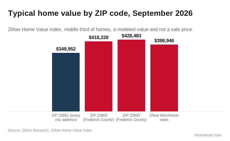
In the year to September 2026, Zillow’s index rose 1.1% in ZIP 22601, from $346,046. It is a modeled typical value for the middle third of homes, not a sale price. The 22602 and 22603 figures are for the Frederick County ZIP codes around the city, which also use a Winchester mailing address. The Census Bureau’s 2023 American Community Survey put the median value of owner-occupied homes in the city at $325,900. Our home prices guide has the longer trend.
The areas
Old Town/North Central. The historic center: the Loudoun Street Mall, the courthouse blocks and older homes around them, with the Boscawen Street bus hub.
North. The smallest area, along North Loudoun and North Cameron streets north of Wyck Street, all in the Virginia Avenue Elementary zone.
Northwest. North of Amherst Street, built around Winchester Medical Center, with Whittier Park.
West Central. The largest area by land, with Handley High, John Kerr Elementary, Glen Burnie and the Abrams Creek Wetlands Preserve.
Central. Just south of downtown, all in the Quarles Elementary zone, with Overlook Green Space.
Northeast. The most addresses of any area, along Berryville Avenue, with five city parks, the Daniel Morgan schools and the closest homes to Exit 315.
East Central. Jim Barnett Park, Shenandoah University and Abram’s Delight, 0.8 miles by road from Exit 313.
Southeast. Apple Blossom Mall and the South Pleasant Valley Road stores, with Weaver Park.
South Central. Between Valley Avenue and the CSX line, with Frederick Douglass Elementary and the Cedar Valley redevelopment district.
Southwest. West of Valley Avenue, with three neighborhood parks off Harvest Drive and Kennedy Drive.
Schools
All seven Winchester Public Schools are Fully Accredited on the state’s School Quality Profiles. Ratings for each school, the calendar and how to register are in our schools guide. Check one address on the division’s WebQuery lookup, which also shows the bus stop.
How we built this
The 10 areas are the City of Winchester’s planning areas; we did not invent our own. The plan gives each boundary in words (for example, “East of CSX tracks, south of Cork St., and north of Jubal Early Dr.”), and we drew those lines on the city’s own street, rail and city limit layers from its open GIS data. For each area we counted the city’s address points, measured how many fall in each elementary zone and council ward (city GIS), and listed the city parks, schools and bus stops inside it. Stores come from OpenStreetMap (© OpenStreetMap contributors); road distances from OSRM routing on OpenStreetMap data; I-81 exit numbers from VDOT signage as listed in our getting around guide. We do not name individual subdivisions or describe who lives in an area. There is no comparison page with nearby cities, because no other Census place of 5,000 or more people lies within 15 miles of Winchester.
Related guides: moving to Winchester, property taxes, getting around and parks and trails.
Frequently asked questions
What are the neighborhoods in Winchester, Virginia?
The city’s 2022 Comprehensive Plan divides Winchester into 10 planning areas: Old Town/North Central, North, Northwest, West Central, Central, Northeast, East Central, Southeast, South Central and Southwest.
What ZIP code is Winchester, Virginia?
Every address in the city of Winchester is in ZIP code 22601. Addresses in 22602 and 22603 also say Winchester but are in Frederick County, which has its own taxes and schools.
Do all Winchester neighborhoods go to the same high school?
Yes. Every city address is zoned for John Handley High School, Daniel Morgan Middle and Daniel Morgan Intermediate. Only the elementary school differs, among four zones that do not follow the planning areas.
What is the typical home value in Winchester?
The Zillow Home Value Index for ZIP 22601, which covers every city address, was $349,952 in September 2026, up 1.1% from a year earlier. Zillow’s Winchester index was $398,946. Both are modeled values, not sale prices.
Which part of Winchester is closest to I-81?
Northeast Winchester is about 0.8 miles by road from Exit 315 (Route 7), and East Central about 0.8 miles from Exit 313 (U.S. 17, U.S. 50 and U.S. 522).
Have your say